


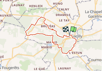
Tour de La Gacilly

eric.deniau
User

Length
15.5 km

Max alt
100 m

Uphill gradient
285 m
Km-Effort
19.3 km

Min alt
3 m

Downhill gradient
287 m
Boucle
Yes
Creation date :
2021-10-17 07:37:52.0
Updated on :
2021-10-17 12:35:18.213
3h45
Difficulty : Very difficult

FREE GPS app for hiking
 SityTrail
IGN / Geographical institutes
SityTrail Plus
The world is yours!
About
Trail Walking of 15.5 km to be discovered at Brittany, Morbihan, La Gacilly. This trail is proposed by eric.deniau.
Positioning
Country:
France
Region :
Brittany
Department/Province :
Morbihan
Municipality :
La Gacilly
Location:
La Gacilly
Start:(Dec)
Start:(UTM)
564644 ; 5290651 (30T) N.
Comments